


Sar Pass Trek
Difficulty: Moderate
Best Time to Visit:
- For Snow: January to March
- For Spring: April, May, and September
Temperature:
- Day: 15°C to 20°C
- Night: 0°C to -7°C
Highest Altitude: 13,800 ft (4,200 m).
Pickup Point: Kasol bus stand
About Sar Pass Trek
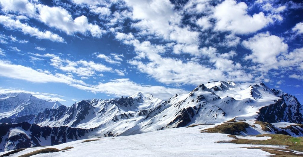
The Sar Pass Trek is a popular trekking route in Himachal Pradesh, India, known for its stunning views of snow-capped peaks, beautiful meadows, and diverse landscapes. Sar Pass Trek is a stunning trek from Grahan village ending in Barhseini in Kullu Valley. The trek is recommended for all those who love adventure, snowy landscapes, and high mountains. Here's a detailed breakdown of the trek:
Overview
The trek starts from Kasol where you will PASS through pine forests, magnificent meadows, snow-capped mountains, and some of the most jaw-dropping landscapes which make Sar Pass one of the best treks for beginners. You will also PASS by a frozen lake (Called Sar in the local dialect) from where it got its name. The total trek distance is 37 km. Once you reach the PASS almost close to 14,000ft, the view from the PASS is absolutely breathtaking because of the majestic mountains of Parvati Valley. This trek will surely give an Adrenalin rush and thrilling experience adorned with alpine forests, wildflowers, and magical valleys. Sir Pass Trek is a high-altitude mountain pass trek located in the state of Himachal Pradesh in India. It is considered to be one of the most challenging and scenic treks in the region. The trek begins from the village of Kasol and takes you through the lush green forests, meadows, and valleys of the Parvati Valley. One of the unique features of Sir Pass Trek is the diverse landscapes and terrain it covers. The trek takes you through pine forests, river streams, and vast meadows, and also involves crossing high-altitude passes covered in snow and ice. This diversity in terrain and landscape makes the trek all the more challenging and exciting for adventure seekers. Another special aspect of the Sir Pass Trek is the breathtaking views it offers. During the trek, you will get to witness stunning vistas of snow-capped peaks, glaciers, and valleys. The trek also takes you through remote villages and hamlets where you can experience the local culture and traditions. Overall, the Sir Pass Trek is a unique and challenging adventure that offers a truly unforgettable experience for trekkers and nature lovers.
Highlights of the Sar Pass Trek
- Scenic Beauty: The trek takes you through beautiful forests of oak, pine, and deodar trees, offering stunning views of the surrounding Himalayan ranges.
- Sar Pass: The highlight of the trek is reaching the Sar Pass, sitting at an altitude of approximately 13,800 feet. The pass offers panoramic views of snow-clad peaks of the Parvati and Tosh Valleys.
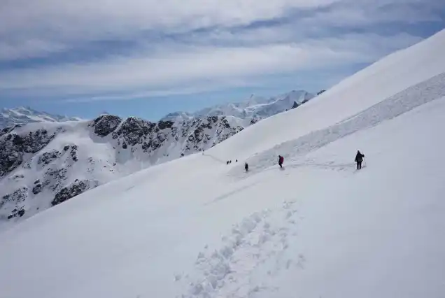
- Challenging Terrain: The trek is moderately difficult with steep ascents, narrow ridges, and tricky descents, providing a thrilling experience.
- Camping Experience: Enjoy camping in scenic spots like Grahan, Min Thach, Nagaru, and Biskeri Thach with stunning views.
- Cultural Interaction: Experience the culture, traditions, and cuisine of local Himachali villages along the trek.
- Adventure Activities: Enjoy rappelling and rock climbing opportunities along the way.
- Hot Springs: Visit the Manikaran hot springs after the trek to relax and rejuvenate.
Safety on the Sar Pass Trek
Your safety is our top priority. We ensure that all trekkers are properly equipped with walkie-talkies, medical kits, and oxygen cylinders to address any emergencies. Our professional guides will be with you every step of the way, providing instructions on navigating the terrain and ensuring your well-being.
In case of any medical emergencies, our team is equipped to transport trekkers back to the base camp or nearest hospital if necessary.
Essential Gear and Medical Supplies
- First Aid Kit: Bandages, antiseptic wipes, adhesive tape, and other essential supplies.
- Oxygen Cylinder: For alleviating symptoms of altitude sickness.
- Personal Medications: Bring any prescribed medications in sufficient quantity.
- Pain Relief: Ibuprofen or acetaminophen for minor injuries.
- Water Purification Tablets: For safe drinking water.
- Emergency Communication Device: Satellite phone or two-way radio for emergencies.
How to get fit for Sar Pass Trek in Himachal Kasol?
Here are some tips to help you get fit for the trek:- Cardiovascular Fitness: Trekking involves long hours of walking and endurance. Engage in activities that improve your cardiovascular fitness, such as jogging, cycling, swimming, or brisk walking. Start with shorter distances or durations and gradually increase the intensity and duration of your workouts over time.
- Leg Strength and Endurance: Trekking requires strong leg muscles to tackle uphill and downhill sections. Incorporate exercises like squats, lunges, step-ups, and calf raises into your fitness routine. Include both strength training and endurance-building exercises for your legs.
- Core Strength: A strong core is essential for maintaining balance and stability during the trek. Include exercises like planks, Russian twists, mountain climbers, and sit-ups to strengthen your core muscles.
- Stair Climbing: Find a nearby staircase or use a stair-climbing machine at the gym to simulate the uphill and downhill sections of the trek. Regular stair climbing workouts will help build strength and endurance in your legs.
- Backpack Training: As you will be carrying a backpack during the trek, gradually increase the weight of your backpack during your training sessions. Start with a lighter load and gradually add weight to simulate the weight you’ll carry during the trek.
- Flexibility and Stretching: Engage in regular stretching exercises to improve flexibility and prevent muscle stiffness. Focus on stretching your leg muscles, lower back, shoulders, and neck.
- Mental Preparation: Trekking requires mental resilience and determination. Prepare yourself mentally by setting realistic goals, visualizing the trek, and staying positive. Practice mindfulness and relaxation techniques to manage stress and keep a calm mindset during challenging moments.
- Hydration and Nutrition: Stay hydrated throughout your training period and during the trek. Maintain a balanced diet rich in carbohydrates, proteins, and essential nutrients to fuel your body and aid in recovery.
- Route:
- Day 1: Reach Our Base Camp Kasol (8:30 am to 9:00 am) Then Trek to Grahan Village
- Route:
- Starting Point: Kasol Bus Stand Base Camp of H.H
- Destination: Grahan Village
- Distance: Approximately 07 kilometers
- Time Required: Around 4-6 hours, depending on your pace and breaks
- Difficulty Level: Moderate
- Trek Details:
- Pickup from Kasol Bus Stand Himalayan Hikers Camp
- Trekking to Grahan Village
- Gradual ascent through the forest
- Scenic views of greenery, pine forests, and streams
- Altitude of Grahan Village: 7,700 feet above sea level
- Difficulty Level:
- Moderate difficulty
- Proper trekking gear recommended
- Important Tips:
- Start early
- Carry enough water and snacks
- Respect the local culture
- Check the weather forecast
- Route:
- Day 1: Reach Our Base Camp Kasol (8:30 am to 9:00 am) Then Trek to Grahan Village
- Route:
- Starting Point: Grahan Village
- Destination: Mini Thatch
- Distance: Approximately 7-8 kilometers
- Time Required: Around 4-5 hours
- Difficulty Level: Moderate
- Trek Details:
- Initial ascent through dense forests
- Scenic landscapes with streams
- Steeper and more challenging ascent
- Mini Thatch: A tranquil meadow for camping
- Difficulty Level: Moderate to difficult
- Important Tips:
- Start early
- Carry sufficient water and snacks
- Follow trail markers
- Take precautions against altitude sickness
- Route:
- Starting Point: Mini Thatch
- Destination: Nagaru
- Distance: Approximately 5-6 kilometers
- Time Required: Around 3-4 hours
- Difficulty Level: Moderate to Difficult
- Trek Details:
- Ascending through alpine meadows
- Steeper rocky paths
- Altitude gain requiring acclimatization
- Panoramic views of Parvati Valley
- Important Tips:
- Start early
- Stay hydrated
- Check weather conditions
- Respect the environment
- Route:
- Starting Point: Nagaru
- Destination: Biskeri Thatch via Sar Pass
- Distance: Approximately 12-13 kilometers
- Time Required: Around 8-10 hours
- Difficulty Level: Difficult
- Trek Details:
- Steep ascent to Sar Pass
- Possible snowfields
- Stunning high-altitude views
- Challenging descent to Biskeri Thatch
- Important Tips:
- Start early
- Stay hydrated and nourished
- Monitor weather conditions
- Use trekking poles if necessary
- Route:
- Starting Point: Biskeri Thatch
- Destination: Pulga Road
- Distance: Approximately 10 kilometers
- Time Required: Around 5-6 hours
- Difficulty Level: Moderate
- Trek Details:
- Scenic descent through forests and meadows
- Passing through small villages
- Well-defined yet uneven terrain
- Important Tips:
- Start early
- Carry essentials (water, snacks, map)
- Respect local communities
- Check weather forecasts
How to Reach Sar Pass Trek
By Air
By Air: The nearest airport to Kasol is Bhuntar Airport, located approximately 31 kilometers away. You can take a flight to Bhuntar Airport from major cities like Delhi or Chandigarh. From the airport, you can hire a taxi or take a local bus to Kasol.
By Train
The nearest major railway station to Kasol is Pathankot Railway Station, which is well-connected to major cities in India. From Pathankot, you can take a bus or hire a taxi to reach Kasol. Another option is to take a train to Chandigarh Railway Station and then continue your journey to Kasol by bus or taxi.
By Bus
By Road: Kasol is well-connected by road and can be reached by bus or taxi from various cities
Here are a few common routes:
- From Delhi: You can take a bus from Delhi to Bhuntar, which is the nearest major town to Kasol. From Bhuntar, you can take a local bus or hire a taxi to reach Kasol, which is approximately 30 kilometers away.
- From Chandigarh: You can take a bus or hire a taxi from Chandigarh to Kasol. The distance between Chandigarh and Kasol is around 275 kilometers.
- From Manali: If you are coming from Manali, you can take a local bus or hire a taxi to Kasol. The distance between Manali and Kasol is approximately 80 kilometers.
Note:
- Please note that we don’t provide timings schedules for transportation before Manali. Subject to various conditions the scheduled timings and availability of particular rides may differ. We recommend trekkers to reach out our teams for any queries. You can drop an email or call us for an initial guided session.
- Our teams will be collecting trekkers at fixed points of airports, railway stations and bus stands.
- It is recommended that unless any delay arrives, trekkers are advised to reach the destinations at least 2 hours prior.
Inclusions
- Accommodation (Guest house, Home stay, Camping)
- Trek equipment: Sleeping bag, mattress, tent (twin sharing), kitchen & dining tent, toilet tent, utensils, and crampon (if required)
- Welcome refreshment
- Three times meals (Veg+egg): Breakfast, Lunch, and Dinner
- All necessary permits and entry fees
- First aid medical kits, stretcher, and oxygen cylinder
- Mountaineering qualified & professional guide and support staff
- Transport Facility Kasol To Kasol (According to itinerary)
- Porter or mule charges for carrying camping equipment and rations
- Morning Tea & Evening Tea with snacks
- Guide Charges
- Hot drinking water
- Trek completion certificate (Approved by Outside Explorers)
- Dry fruits, chocolates, biscuits, toffees provided during the trek
Exclusions
- Porter/mule for personal bags
- Any meals or services not mentioned in inclusions
- Any charges for video cameras or still cameras
- Charges for soft drinks or any other beverages
- Personal expenses such as tips, laundry, or telephone calls
- Any costs arising from unforeseen circumstances like landslides, bad weather, or roadblocks
- Food during transit
- Insurance
- Mules or porter to carry personal luggage
- Anything not specifically mentioned under the inclusions
- Any kind of emergency evacuation charges
🏔️ Things to Carry for This Trek
🧳 Essentials
- 🆔 Government ID (Aadhar, Passport, etc.)
- 📄 Permits & Trek Bookings
- 💵💳 Cash (Limited ATMs in Remote Areas)
- 📍 Trek Map & Itinerary
🎒 Backpack & Gear
- 🎒 Backpack (50-60L) with Rain Cover
- 🥾 Good Quality Trekking Shoes
- 🦯 Trekking Pole
- ⛺ Sleeping Bag (if required)
- 🔦 Headlamp / Torch with Extra Batteries
🧥 Clothing & Accessories
- 🧥 Waterproof Jacket / Windcheater
- 🩳 Quick-Dry T-shirts & Trek Pants
- 🧤 Woolen Gloves, Socks & Cap
- 🕶️ UV Protection Sunglasses
- 🩲 Thermal Innerwear (for high-altitude treks)
🛠️ First Aid & Personal Care
- 💊 Basic First Aid Kit & Personal Medicines
- 🧴 Sunscreen & Lip Balm (SPF 50+)
- 🚿 Wet Wipes & Sanitizer
- 🦟 Mosquito & Insect Repellent
📱 Electronics & Miscellaneous
- 📱🔌 Phone & Charger
- 🔋 Power Bank
- 📸 Camera / GoPro (optional)
- 🍫 Dry Fruits, Energy Bars & Snacks
- 🚰 Water Bottles / Hydration Pack
Why Choose Triptoo for the Sar Pass Trek?
Triptoo offers a well-organized and adventure-packed trekking experience with expert guides, comfortable campsites, and delicious meals. Our team ensures safety, proper acclimatization, and a memorable journey through the stunning landscapes of Sar Pass.
What type of food we serve on trek?
What is the best time to do the Sar Pass Trek?
How difficult is the Sar Pass Trek?
What is the starting and ending point of the trek?
Do you need a permit for the Sar Pass Trek?
