

Roopkund Trek – The Mystery Lake Trek.
Difficulty: Easy
Best Time to Visit:
- For Snow: January to March
- For Spring: April, May, and September
Temperature:
- Day: -1°C to 10°C
- Night: -8°C to -3°C
Highest Altitude: 5,029m (16,499ft)
Pickup Point: Dehradun
Roopkund Trek-A Mestery lake trek
Introduction to Roopkund Trek
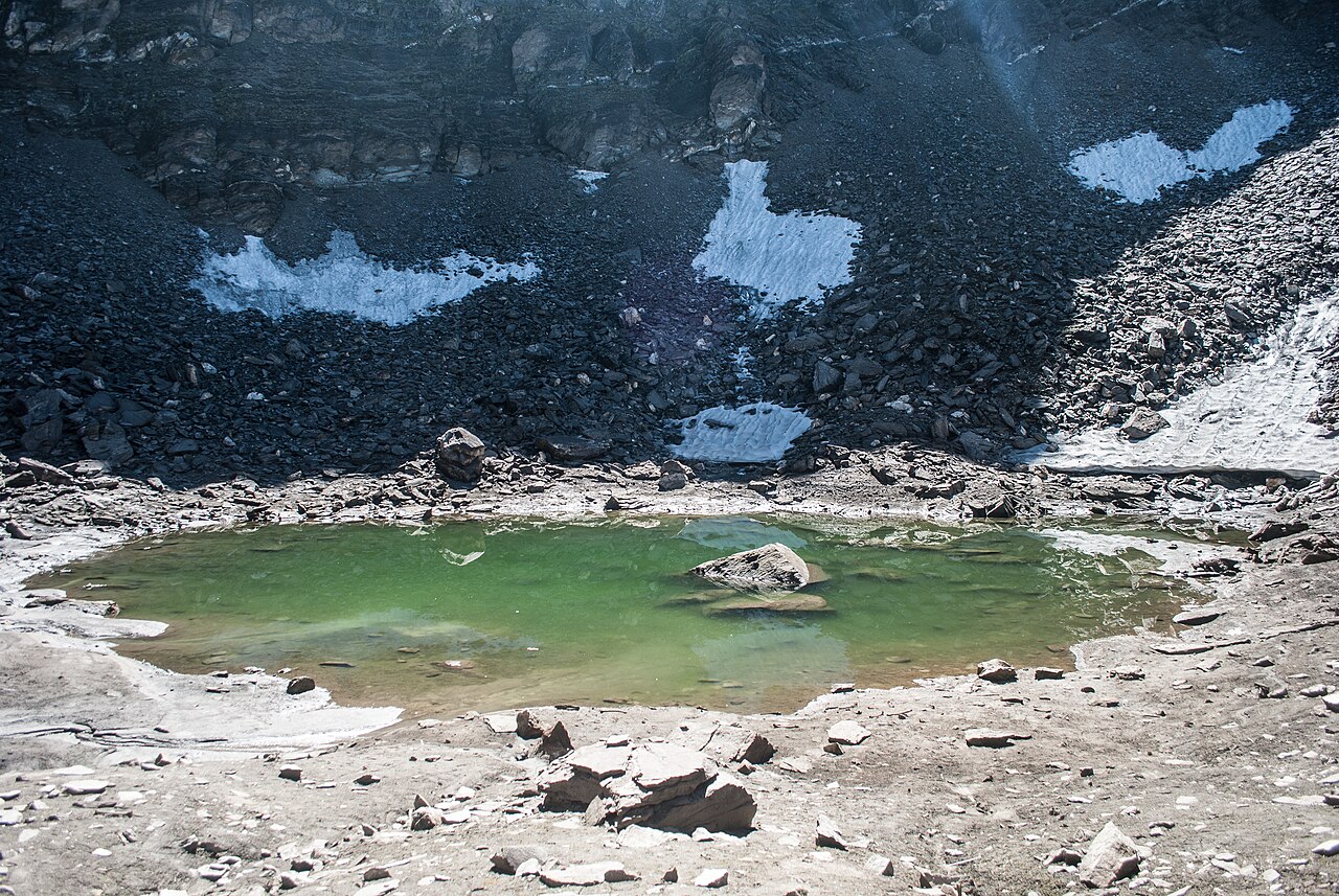
The Roopkund Trek is the most popular trekking destination in Uttarakhand, located in the Garhwal Himalayas of India. Situated at an altitude of 16,156 feet, Roopkund Lake is also known as the "Mystery Lake" due to the human skeletons found at its bottom, which have intrigued trekkers for years.
Why Roopkund Trek is Popular
Roopkund Trek is known for its stunning beauty, unique history, and thrilling adventure. The trek takes you through virgin forests, vast meadows, and snow-capped mountains. The lake itself, surrounded by glaciers, offers a divine sight, especially when you spot the human skeletons from the Paleolithic age, clearly visible when the snow melts. This trek will surely satisfy your thirst for adventure.
Main Highlights of Roopkund Trek
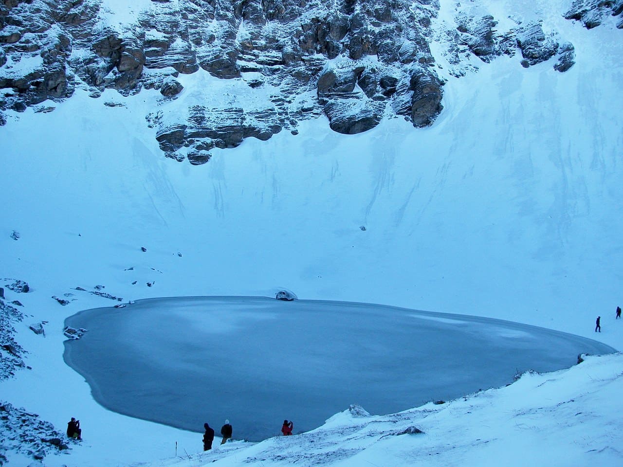
- Roopkund Lake: Located at 4,800 meters, the main highlight of the trek. The lake is famous for the human skeletons found in its depths, which give it the name "Skeleton Lake".
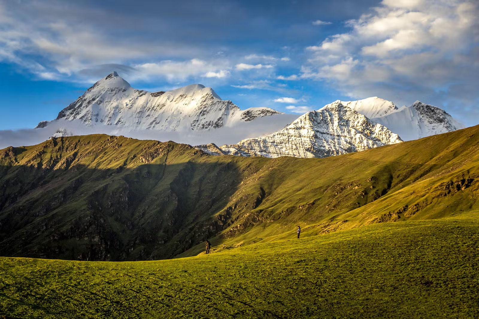
- Stunning Views: The trek offers breathtaking views of the Trishul, Nanda Ghunti, and Chaukhamba peaks, along with alpine meadows, forests, and waterfalls.
- High Altitude Passes: The trek involves crossing the Roopkund and Junargali passes, providing panoramic views of the surrounding mountains and valleys.
- Cultural Experience: Passing through traditional villages, trekkers can interact with locals and explore their unique way of life.
- Flora and Fauna: The trek passes through the Nanda Devi Biosphere Reserve, where you may spot Himalayan musk deer, blue sheep, and a variety of birds and butterflies.
- Adventure Activities: River crossing, rappelling, and rock climbing make this trek exciting and challenging.
Scenic Views Along the Trek
The Roopkund Trek offers magnificent views of snow-capped mountains and alpine meadows. The dense oak and rhododendron forests along the way enhance the beauty. The trek passes through Bedni Bugyal and Ali Bugyal, two stunning alpine meadows that provide surreal views. Other peaks visible during the trek include Neelkanth, Kedarnath, Chaukhamba, and Kedar Dome.
Snow-Covered Forests and Unique Experience
The trek also takes you through snow-covered forests, where you'll spot Himalayan wildlife. The unspoiled natural beauty makes the trek a perfect getaway for those seeking an adventure in a relatively peaceful environment, away from the crowded routes of other Himalayan treks.
Important Information about Roopkund Trek
The trek spans a distance of 64 km, which is usually covered in 7-8 days. The trek reaches an altitude of 16,156 feet at Roopkund Lake, making it a moderate difficulty trek. Proper gear and clothing for sub-zero temperatures are necessary due to the high altitude.
Key Information:
- Distance: 64 km
- Maximum Altitude: 15,756 feet (Roopkund Lake)
- Duration: 7-8 days
- Difficulty Level: Moderate
- Best Time to Visit: May-June, September-October
Best Time to Visit Roopkund Trek
The best time to visit the Roopkund Trek is during the pre-monsoon (summer) and post-monsoon (autumn) seasons. The months of May, June, and September to October offer the best weather conditions. The summer months can be colder, with harsh winds, but are great for witnessing the lake in its frozen state. The autumn months offer clear skies and are perfect for seeing the skeletons visible in the lake.
Altitude we are going to cover in roopkund
- Lohajung Base: 7,663 feet
- Didna Village: 8,096 feet
- Ali Bugyal: 11,320 feet
- Patar Nachauni: 12,818 feet
- Bhagwabasa Camp: 14,126 feet
- Roopkund Lake: 15,756 feet
Difficulty Level
The Roopkund Trek is considered a moderate trek. It involves a mild climb from Lohajung to Roopkund, and after reaching the summit, it is mostly a downhill journey. The trek is suitable for those with good fitness levels and a passion for trekking.
Is Roopkund Trek Safe?
Yes, the Roopkund Trek is considered safe for trekkers. All safety measures are taken into account, with professional guides leading the trek. However, it is important to be cautious of high-altitude medical conditions, especially for beginners.
Weather Conditions
The weather varies according to the season. During May to October, the weather is moderate with cold nights and mild daytime temperatures. The monsoon season is less harsh, making it a good time to trek. The autumn season offers the most favorable weather for trekking.
- – 210 km – 9/10 Hours journey
- – By taxi
- –Lohajung – 7,663 feet
- – Our Home stay – on twin share basis
- Our vehicle picks you up from Kathgodam Railway station and en routes to Lohajung, the journey is of 9/10 hours, there will be one or two breaks, have your breakfast and lunch on the way.
- We will go through the region of Kumaon and valleys of Shivalik mountain ranges.
- The road takes you through picturesque places with beautiful forests and curves with mountain views in the backdrop.
- There is a direct road from Gwaldam to Deval but it is damaged due to heavy rains so the other route is preferred, from there we will reach Deval.
- Deval is a village from where one can purchase food and kerosene for the journey, now from Deval drive is towards Lohajung.
- Road to Lohajung is windy and curvy and an experienced driver is needed to drive on those roads.
- Temperature is mostly cold here as we gain height while going upwards and it is rainy and foggy most of the time.
- Dinner and overnight stay in a hotel or home stay
Total distance
Mode of journey
Altitude
Night stay
- Trek Distance – 5.5 km – 4/5 Hours journey
- Mode of journey – On foot
- Altitude – Ghairoli Patal – 10,100 feet
- Night Stay – Our Camp site – on twin share basis After having proper breakfast your trek begins, you have to walk on levelled ground, reach village Wan from here you have to walk on flat ground to reach Kulling which is 6 km away from Lohajung. Kulling is a small village with few people living there, this place looks peaceful. You can spot variety of birds here, the climate is invigorating; you can feel the freshness in the air. Take a break here after your break descends to the village, the trail is narrow which takes you through houses and pasturelands to a small stream, the water in this stream comes from Neel Ganga. Continue walking and cross the bridge, now you have to climb a ridge, this is a steep climb, it ends at an altitude of 8,000feet at village Didna. The trail is through the evergreen alpine forest. Reach the top of the ridge it will take two hours to reach there, the views from here are entrancing and magnificent, you will see open lands on the lap of the mountains. Didna is a famous village where trekkers stay. Reach your destination Ghairoli Patal you will reach there through dense forest, the campsite looks alluring, set up your camps in the desired area, hot lunch will be served dinner and overnight stay in tents.
- Trek Distance – 10 km – 6/7 Hours journey
- Mode of journey – On foot
- Altitude – Ali Bugyal – 11,506 feet
- Night Stay – Our Camp site – on twin share basis Have your breakfast in Ghairoli Patal and start your trek to Bedni Bugyal, today you will go through the village of Ali Bugyal, this village is at an altitude of 3410m. Ali Bugyal is visible from Didna as it is on the top of the mountain. You have to climb the mountain to reach Ali Bugyal, the trail is not steep, but it is slightly upwards, on the way there are shepherd huts, known as Tolpani. Now the other climb is steep, but it takes you through picturesque places, there are trees of Oak, Birch, and Rhododendrons only these trees grow there, on the way you can see local people with their sheep, you can communicate with them. During the spring season the valley gets more beautiful with exotic views blooming flowers make this valley look divine. You will see the receding treeline and plain grasslands after some hours of the climb the Ali Bugyal unfolds in front of you, it has got fascinating views, there is inherent beauty in this place. In the month of summer, you can see some beautiful white horses and cows grazing the fields, the fields are all covered by grass and flowers. From here you can spot the tallest mountain peaks Mrigthuni and Mt. Trishul, the views are the main attention seeker. Cross the soothing meadows and trek for more half an hour to reach Bedni, there is our campsite where we will set up our tents. Have your lunch intents and then visit Bedni Kund which is a temple nearby. Garhwal Himalayan ranges are also visible from here if the weather is clear. Dinner and overnight stay in tents.
- Trek Distance – 07 km – 4/5 Hours journey
- Mode of journey – On foot
- Altitude – Patar Nachauni – 12,818 feet
- Night Stay – Our Camp – on twin share basis The morning views of Bedni Bugyal are unmatched there are lush green trees and soothing greenery is all around. Sunrise looks mesmerizing from there. According to Hindu mythology, Lord Brahma created Vedas here. Have your breakfast and then depart to Patar Nachauni which is 5 km away. The trail is an easy climb following the trail from Bedni campsite is visible till 3km further then it disappears. Continue trekking and you will sew the other side of the ridge which is entirely different and beguiling, different scenic views in one trek. It is a delight for trekkers, have full view of charming mountains like Nanda Ghughunti and Trishul. You can see some waterfalls and narrow streams flowing through the meadows, they add beauty to them. Reach your campsite Patar Nachauni, it is a meadow from where you get spectacular sight of mountains and the clouds touch the peaks, it looks wonderful, enjoys sightseeing snacks and meal there and then overnight stay in tents.
- Trek Distance – 4.5 km – 4/5 Hours journey
- Mode of journey – On foot
- Altitude – Bhagwabhasa camp – 14,126 feet
- Night Stay – Our Camp – on twin share basis After breakfast, start your trek to Bhagwabhasa (14,126 feet), it is a 6km long trek, and it takes 4 to 5 hours to reach there. The story behind this place is dancers were converted into stones because goddess Nanda cursed them. Patthar- stone Nachauni- dancers. Walk towards Bhagwabhasa and the same trail will take you to Kalu Vinayak temple, to reach the temple you have to travel 2kms by gaining 200ft altitude. The path isn’t easy, it is uneven and zig-zag in shape so walk carefully because a single mistake can be very dangerous, this climb is worth your every effort because the top will mesmerize you. It is very windy there because the altitude increases, oxygen decreases at this level, take breaks and drink water while ascending. The temple has a traditional design and made of stones but it looks beautiful and unique. You can feel spiritualty in the atmosphere there. Visiting a temple at such a high altitude is very interesting and people who love to explore can only understand this. When you reach the temple from there you can see Roopkund the place which you are going to visit the next day and your final destination Also, The view of glittering beautiful amongst all Mt. Trishul on one side and Nandaghunti on the other. Now, follow the trail which not leveled, it will take you to Bhaguabasa which is 1 km away from here. The trail is rocky and is not easy to cross, take breaks and continue walking reach Bhaguabasa, the place is a barren piece of land but during monsoon, flowers bloom in this region. Set up your tents there and dinner and overnight stay in tents.
- Distance – 10 km – 8/9 Hours journey
- Mode of journey –On foot
- Altitude – Roopkund – 15,756 feet
- Night Stay – Camp site – on twin share basis Early morning we will provide hot tea or coffee then we will leave for Roopkund with packed breakfast because in the morning you can have a clear view of the mountains and later they get covered by the clouds. Today trek to Roopkund is difficult ascending and 400 meters to Junargali Dhar Top summit (5029 meters). Roopkund is a glacial lake at high altitude also known as “Mystery Lake” because the human skeletons. from ancient times are found here and can be seen inside the lake when the ice melts. You can spot those skeleton on the edge of the lake, you will be lucky enough if you spot them. After a steep climb, you will see Nanda Devi temple visit that temple from there you can get scenic views, click pictures spend time there and if the weather is good you can visit Junargali Top which is (16,700 feet) when you reach top it is very windy there, you will be amazed while standing at Junargali top, the sense of confidence you will feel would be one of the best feeling. Now return to Patar Nachauni you have to go through Bhagwabhasa the descend is more difficult because while ascending trail was steep and it the trail becomes thrilling while coming down, Follow the same trail go to a cave-like structure which is known as Bhagwabhasa, descend and you will reach Patthar Nachauni your campsite. Spend your time in peace and relax your body and mind. Dinner and overnight stay in tents.
- Distance – 15 km – 8/9 Hours journey
- Mode of journey –On foot
- Altitude – Lohajung – 7,663 feet
- Night Stay – Home stay – on twin share basis Today is the last day of your trek so cherish these moments relish the sunrise and move towards Lohajung. Today from Bedni Bugyal we will go from another route which goes to Lohajung, the trail is through the dense forest there are big and thick trees, this place is rich in flora and fauna. At Wan village, A famous temple of Latu Devta in which there is puja organized by the villagers. You can visit this temple or take a break here. The trail is simple and with the trail, you will spot wooden huts and further you will see the road diverged into two paths. Descend and you will enter a forest region and there are trees all around. You can hear birds chirping which is the trail is varying so walk carefully so that you don’t get slipped. walk further cross some yards and you will reach Gahroli Patal which is opening of a forest. Then reach the banks of river Neel Ganga continue walking and visit a wan village, it is a big village surrounded by mountains and from there back to Lohajung by Taxi. Dinner and overnight stay at tourist guest house.
- Distance – 210 km – 8/9 Hours journey
- Mode of journey –By taxi
- Depart for Kathgodam and reach the Railway station by 6:30 pm – 7:00 pm.
How to Reach Roopkund Trek
By Air
Jolly Grant Airport is the airport serving Dehradun, located about 25 km from the city. There is a daily flight from Delhi to Dehradun.
By Train
Take the overnight train to Dehradun from Delhi:
- Nanda Devi Express - Train no: 12205 (Departure: 11:50 PM, Arrival: 5:40 AM)
- Dehradun Express - Train no: 12687 (Departure: 9:10 PM, Arrival: 5:00 AM)
By Bus
There is regular bus service from Delhi to Dehradun, from Delhi’s ISBT Kashmere Gate.
We recommend taking only government buses from ISBT Kashmere Gate. Private buses ply from outside ISBT, and they are not trustworthy.
Usually, buses drop you at Dehradun ISBT. From there, you have to reach Dehradun Railway Station.
Note:
- Pick-up is included in the cost of the trek.
- You will reach Sankri by 5:00 PM.
- Food from Dehradun to Sankri is not included in the trek cost.
- Transport will be arranged from Dehradun Railway Station at 6:30 AM.
Inclusions
- Accommodation (Guest house, Home stay, Camping)
- Trek equipment: Sleeping bag, mattress, tent (twin sharing), kitchen & dining tent, toilet tent, utensils, and crampon (if required)
- Welcome refreshment
- Three times meals (Veg+egg): Breakfast, Lunch, and Dinner
- All necessary permits and entry fees
- First aid medical kits, stretcher, and oxygen cylinder
- Mountaineering qualified & professional guide and support staff
- Transport from Dehradun to Sankri and return (According to itinerary)
- Porter or mule charges for carrying camping equipment and rations
- Morning Tea & Evening Tea with snacks
- Guide Charges
- Hot drinking water
- Trek completion certificate (Approved by Outside Explorers)
- Dry fruits, chocolates, biscuits, toffees provided during the trek
Exclusions
- Porter/mule for personal bags
- Any meals or services not mentioned in inclusions
- Any charges for video cameras or still cameras
- Charges for soft drinks or any other beverages
- Personal expenses such as tips, laundry, or telephone calls
- Any costs arising from unforeseen circumstances like landslides, bad weather, or roadblocks
- Food during transit
- Insurance
- Mules or porter to carry personal luggage
- Anything not specifically mentioned under the inclusions
- Any kind of emergency evacuation charges
Clothing & Footwear
- ✅ Warm Layered Clothing – Thermal wear, fleece jacket, down jacket
- ✅ Waterproof Jacket & Poncho – Essential due to unpredictable weather
- ✅ Trekking Pants & Comfortable T-Shirts – Avoid jeans
- ✅ Woolen Socks & Gloves – Protection from cold
- ✅ Trekking Shoes with Good Grip – Waterproof recommended
Essential Gear
- ✅ Backpack (30-50L) – Lightweight and sturdy
- ✅ Trekking Pole – Reduces knee strain
- ✅ Rain Cover for Backpack – To protect belongings
- ✅ Sunglasses & Sunscreen (SPF 50+) – UV protection at high altitude
- ✅ Torch/Headlamp – Useful for night-time
Personal Items & Accessories
- ✅ Water Bottle & Hydration Pack – Stay hydrated
- ✅ Energy Bars/Dry Fruits – Quick energy source
- ✅ Personal Medications & First Aid Kit – Band-aids, painkillers, Diamox (for altitude sickness)
- ✅ Toiletries – Biodegradable soap, toothbrush, wet wipes, sanitizer
Electronics
- ✅ Power Bank & Extra Batteries – Limited electricity at Kedarnath
- ✅ Camera/Smartphone – To capture the scenic beauty
Important Documents
- ✅ ID Proof (Aadhar Card/Voter ID) – Required for temple entry
- ✅ Kedarnath Yatra Registration – Mandatory (online or at registration centers)
Why should I book my trek with Triptoo?
Triptoo offers expert-guided treks, well-planned itineraries, quality camping gear, and 24/7 support to ensure a safe and memorable trekking experience. We handle permits, meals, and logistics, so you can focus on enjoying the adventure.
What type of food we serve on trek?
Is it safe Trek?
Do I need a permit for the trek?
What kind of accommodation is available during the trek?
Is this trek safe?
