

Pangarchulla Trek – A Himalayan Adventure
Difficulty: Easy
Best Time to Visit:
- For Snow: January to March
- For Spring: April, May, and September
Temperature:
- Day: -1°C to 10°C
- Night: -8°C to -3°C
Highest Altitude: (4,590m / 15,100ft)
Pickup Point: Dehradun
About Pangarchulla Trek
Pangarchulla Peak Trek is at an elevation of 15,096 feet and is a 5-night 6-day thrilling sojourn. On this trek, you go through the pilgrimage sites of Uttarakhand. The trek starts and ends at Dhak village which is some kilometers away from the base camp “Joshimath market”. Pangarchulla peak is great in summers and thrilling in winters; this is a delight for adventure enthusiasts in the Himalayas Pangarchulla Peak is located in Chamoli District of Uttarakhand and it extends from 15096 feet, Trek – A beautiful mini peak near to Kauri Pass trek in Uttarakhand. The Pangarchulla Peak trek is a popular and challenging trek located in the Garhwal region of Uttarakhand, India. The trek offers breathtaking views of snow-capped peaks, beautiful meadows, and dense forests.
Best Time to Do Pangarchulla Peak Trek?
Pangarchulla Trek is a very beautiful uphill trek in District Chamoli Uttarakhand Himalayas, The Pangarchulla Trek is great for those people who have a great passion for mountaineering and consider it a special purpose in their life. We are the local people of Uttarakhand who are doing this trek for years, we have every experience related to this trek. The right time to do this trek is in Winter and summer especially in the months of May and June, greenery little bit of snow on the summit point is found in abundance here, which makes your trek very memorable and also a little difficult. So this trek should not be considered too easy During the day the temperature of the Pangarchulla trek is around ( Winter Day time -5°C to -10 °C and during the night the temperature comes down to -10 °C to -15 °C Views and treks in Pangarchulla trek provide a lot of peace to the mind during the day, while you wake up from one wake to another, Pangarchulla can always be one of the most close treks in your heart.
How Difficult is Pangarchulla Trek?
Pangarchulla trek is not very difficult and not easy either, this trek comes in a moderate and difficult level, I myself have done this trek sometimes with, people who are trekking for the first time, we have done the entire trek, they used to need help somewhere, which we and our team used to help. This trek is a bit difficult, but if your fitness is good and you have it in your mind that I want to trek then you can do it absolutely. Where help is needed, our guides will support you, you just have to be strong and capable of the trek. One thing is that all you can do is to have courage and I myself am passionate.
Is Pangarchulla safe ?
Pangarchulla Trek is a safe trek if you are going with a good trekking team which you must know before booking yourself, It is important for you to know whether the bow trekking organization with which we are going is right or not, And if possible, trek with a local trekking organization, you can do the same help all the time. then your trek can be very good and memorable The minimum age required to trek the Pangarchulla peak trek is 15 years and the maximum 55 years. The rest depends on your fitness.
Why is Pangarchulla Trek a Must-Do Trek ?
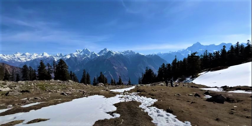
The Pangarchulla Trek combines mesmerizing landscapes with an adventurous climb, offering you a perfect balance of both serenity and thrill. Embrace the beauty of the Kuari Pass, which is fondly called the “Doorway to Heaven,” because of its beauty that takes you close to the vast Himalayan mountains. Taking you through oak and rhododendron forests to high-altitude meadows, the Pangarchulla trek is rich in biodiversity. You may even spot musk deer, or vibrant bird species, adding to the charm of your journey.
The trek takes you through expansive bugyals that seem to stretch endlessly. These lush green carpets, framed by towering peaks, are picture-perfect and provide peaceful resting spots.
As you walk through villages, cross streams, and climb rocky trails you get to witness the raw beauty and culture of the Himalayas, it is a journey that connects you deeply with nature.
The climb to Pangarchulla Peak is both challenging and fulfilling. The steep ascents, ridges, and snow-covered paths test your endurance, but the views are worth it all.
The final ridge leading to the summit is an adrenaline-pumping experience. It offers sweeping views of the surrounding mountains including Chaukhamba, and Hati-Gauri.
Reaching the summit of Pangarchulla Peak is a moment of pure joy. Standing amid glittering snow with the vast expanse of Himalayan peaks around you is a feeling you would surely embrace forever.
What Can you expect during the Pangarchulla Trek?
Pangarchulla Trek is a moderate to difficult grade trek so basic physical fitness is necessary if you truly want to enjoy the experience. The summit push might sound tough, but it is manageable with prior preparations and teamwork. You get beautiful vantage points during the trek with a wide panoramic view of the Himalayan range, take your time and soak in the beauty.
The best time to do the Pangarchulla trek is during the Spring. During the months of March and April, the weather during the daytime is usually sunny with mildly cold evenings, however, the temperature drops exponentially post-sundown. The trail is vibrant with blooming rhododendrons and offers clearer skies for panoramic views.
The daytime temperature at Pangarchulla is around 15°C while the night temperature can drop as low as -5°C or below. So carry enough warm layers as nights can be pretty cold. It's crucial to prepare for the weather conditions. Proper gear, layered clothing, and waterproof shoes are essential for trekking in snow or rain-prone areas. Sometimes, there can be sudden surprise showers in Pangarchulla so you need to be prepared for that too.
The Pangarchulla Peak trek is a journey full of experiences and challenges that would inspire you to trek even more. From navigating snow-laden ridges to soaking in panoramic Himalayan vistas, every moment offers something special. This trek is a perfect opportunity to challenge yourself, connect with nature, and create lifelong memories. With proper preparation and the right mindset, the Pangarchulla Trek promises an experience that will leave you inspired and craving more adventures.
Who Can Participate
Age Requirement:
Minimum 14 years
First-timers are welcome, though prior trekking experience is preferred. Good fitness is a must.
Fitness Criteria:
The Trekker should have sufficient stamina to cover 5 km of distance by jogging in 30 minutes without stress or 10 km of distance in 70 minutes without stress
If the trekker prefers cycling he/ she should be able to cycle 18 km of distance in 50 minutes.
If the trekker wants to carry a backpack then he/she should be able to carry a 10-12 kg backpack. If opt Off-load option then the trekker should be able to carry 3-5 kg backpack.
If a trekker's BMI is more or less than the normal range (18-27), please consult our Trek Coordinator before booking.
- Total distance – 286 km – 9/10 Hours journey
- Mode of journey – By taxi
- Altitude – Joshimath– 6152 feet
- Night stay – Hotel – on twin/three share basis
- Himalayan Hikers organizes transport for trekkers from Haridwar Railway Station in the morning which will leave for Sankri around 6:00 am to 7:00 am.
- Rishikesh to Joshimath is a picturesque journey through the majestic Himalayan landscape, offering breathtaking views of valleys, rivers, and snow-capped peaks. Here’s a suggested plan for your trip:
- Pickup from Rishikesh: Start your journey from Rishikesh, a spiritual town situated on the banks of the Ganges River. You can hire a taxi or Tempo Traveller for a comfortable ride to Joshimath. The journey typically takes around 9-10 hours depending on road and weather conditions.
- Route: The most common route from Rishikesh to Joshimath is via Devprayag, Srinagar, Rudraprayag, Karnaprayag, Chamoli, and finally reaching Joshimath. This route offers stunning views of the Himalayan ranges, lush green valleys, and rivers flowing through narrow gorges.
- Views: Throughout the journey, you’ll be treated to panoramic views of the Himalayas, including peaks like Nanda Devi, Trishul, and Dronagiri. The route passes through several small towns and villages, allowing you to experience the local culture and lifestyle of the Garhwal region.
- Joshimath Stay: Joshimath serves as a base camp for trekkers heading to popular destinations like Valley of Flowers, Hemkund Sahib, and Auli. There are various accommodation options available in Joshimath ranging from budget guesthouses to mid-range hotels. You can choose a place to stay based on your preferences and budget. Activities in Joshimath: While in Joshimath, you can explore the nearby attractions such as the Narsingh Temple, Shankaracharya Cave, and Kalpavriksha. You can also take a cable car ride to Auli, known for its skiing slopes and panoramic views of the Himalayas.
- Devprayag: After traveling for about 70 kilometers from Rishikesh, you’ll reach Devprayag, where the Alaknanda and Bhagirathi rivers merge to form the Ganges. The confluence point is a sight to behold, with the contrasting colors of the two rivers meeting amidst the towering mountains.
- Devprayag to Srinagar: From Devprayag, the road continues along the banks of the Alaknanda River. The scenery becomes more dramatic as you ascend into the mountains. You’ll pass through small towns and villages nestled in the valleys, with terraced fields and dense forests surrounding the road. Srinagar to Rudraprayag: As you proceed further, the road follows the course of the Alaknanda River, offering stunning views of the river gorge and the mountains beyond. Rudraprayag, another important town on the route, is known for its confluence of the Alaknanda and Mandakini rivers. Rudraprayag to Karnaprayag: The journey continues through picturesque mountain landscapes, with the road winding its way up and down the valleys. You’ll pass through dense forests, cascading waterfalls, and terraced fields, with the snow-capped peaks of the Himalayas visible in the distance.
- Karnaprayag to Chamoli: The route from Karnaprayag to Chamoli offers some of the most breathtaking views of the journey. You’ll pass through narrow gorges and steep cliffs, with the river flowing far below. The road climbs higher into the mountains, offering panoramic vistas of the surrounding peaks.
- Chamoli to Joshimath: The final stretch of the journey takes you through mountainous terrain, with the road hugging the slopes of the Himalayas. As you approach Joshimath, you’ll be greeted by views of snow-capped peaks and dense forests. The town of Joshimath itself is located at an altitude of over 6,000 feet and offers stunning views of the surrounding mountains
- Additional Tips:
- Make sure to carry some warm clothing as the weather in Joshimath can be chilly, especially in the evenings and early mornings.
- It’s advisable to start early from Rishikesh to avoid traffic and reach Joshimath before nightfall.
- Keep some snacks and water handy for the journey as there might be limited options for food and refreshments en route.
- Overall, your trip from Rishikesh to Joshimath promises to be a memorable experience, offering stunning natural beauty and a glimpse into the rich cultural heritage of the Garhwal region. Enjoy your journey!.
- Total distance – 17 km – 4/5 Hours journey
- Mode of journey – By taxi -12 km – On foot – 3.5 Km
- Altitude Gulling camp – 9,832 feet
- Night Stay – our Camp – on twin share basis
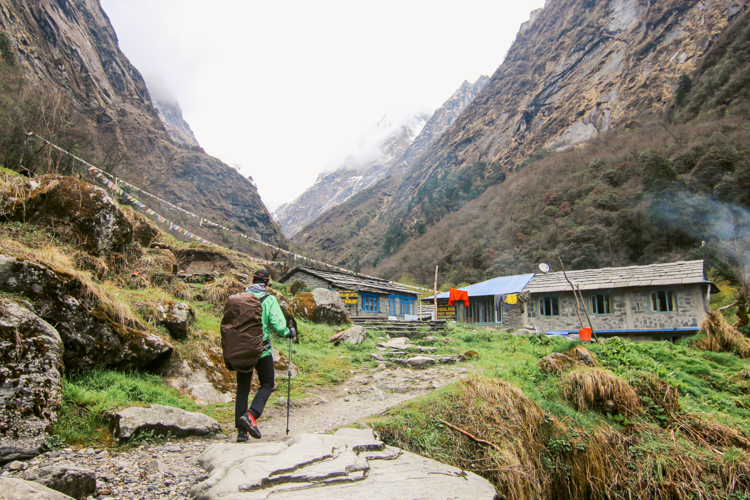
- Driving from Joshimath to Dhak is a short distance of approximately 12 kilometers, and then embarking on a trek to Gulling Camp offers a wonderful opportunity to immerse yourself in the natural beauty of the Himalayas. Here’s what you can expect:
- Drive from Joshimath to Dhak: The drive from Joshimath to Dhak is relatively short and should take around 30-45 minutes by taxi. The road may be narrow and winding at some points, but the views along the way are likely to be stunning, with snow-capped peaks and lush green valleys.
- Trek from Dhak to Gulling Camp:
- Distance: The trek from Dhak to Gulling Camp is approximately 8-10 kilometers, depending on the specific route you take. Level of Difficulty: The trek is considered to be of moderate difficulty. While it’s not extremely strenuous, it does involve ascending and descending trails through forested areas and possibly some rocky terrain. It’s advisable to have a moderate level of fitness for this trek.
- Route: The route from Dhak to Gulling Camp may vary, but it generally involves trekking through dense forests, crossing streams, and ascending gradually towards the campsite. You may encounter some steep sections, especially as you gain elevation.
- Views: Along the trek, you’ll be treated to breathtaking views of the surrounding mountains, valleys, and forests. The Himalayan landscape is truly majestic, with snow-capped peaks towering above lush greenery.
- Duration: The trek from Dhak to Gulling Camp typically takes around 3-4 hours, depending on your pace and the trail conditions.
- Gulling Camp:
- Location: Gulling Camp is situated amidst pristine natural surroundings, offering a serene escape from the hustle and bustle of city life. The campsite is likely to be nestled in a scenic location, surrounded by towering trees and with panoramic views of the mountains.
- Facilities: Depending on the arrangements, the campsite may offer basic facilities such as tents, sleeping bags, and meals cooked by the support staff. It’s advisable to check in advance regarding the amenities provided at the campsite.
- Experience: Spending a night at Gulling Camp is a unique experience, allowing you to reconnect with nature and enjoy the tranquility of the Himalayas. You can relax around a campfire, gaze at the starlit sky, and listen to the sounds of the forest.
- Overall, the journey from Joshimath to Dhak followed by the trek to Gulling Camp offers an opportunity to explore the pristine beauty of the Himalayas and immerse yourself in the wilderness of Uttarakhand.
- Trek Distance – 05 km – 4/5 Hours journey
- Mode of journey – On foot – 05 Km
- Altitude – Jangal camp – 11072 feet
- Night Stay – our Camp – on twin share basis
- The trek from Gulling Top to Khullara Camp is an exhilarating adventure that takes you through some of the most stunning landscapes in the Himalayas. Here’s what you can expect:
- Distance and Elevation: The distance from Gulling Top to Khullara Camp is approximately 7-8 kilometers, with an elevation gain of around 300-400 meters. Khullara Camp is situated at an altitude of 13,989 feet (about 4266 meters) above sea level.
- Level of Difficulty: The trek from Gulling Top to Khullara Camp is considered to be moderately difficult to challenging. The terrain involves steep ascents and descents, rocky trails, and possibly some sections with loose gravel or scree. Additionally, the high altitude may pose challenges for some trekkers, so it’s important to be adequately prepared and acclimatized.
- Route:
- The route from Gulling Top to Khullara Camp typically follows a well-defined trail that meanders through alpine meadows, rocky terrain, and possibly some patches of snow, depending on the season.
- You’ll start by descending from Gulling Top before gradually ascending towards Khullara Camp. The trail may pass through lush green valleys, offering panoramic views of the surrounding mountains.
- As you gain elevation, the landscape may become more rugged, with rocky outcrops and scree slopes. The final stretch of the trek to Khullara Camp may involve a steep ascent, leading you to the high-altitude campsite nestled amidst the mountains.
- Views:
- Throughout the trek, you’ll be treated to breathtaking views of snow-capped peaks, including some of the prominent summits of the Garhwal Himalayas. The route offers panoramic vistas of the surrounding valleys, glaciers, and alpine meadows, providing ample opportunities for photography and soaking in the natural beauty of the region. As you approach Khullara Camp, you’ll be rewarded with stunning views of the towering mountains surrounding the campsite, creating a truly awe-inspiring backdrop for your adventure.
- Duration:
- The trek from Gulling Top to Khullara Camp typically takes around 4-6 hours, depending on your pace, trail conditions, and stops along the way. It’s advisable to start early in the morning to make the most of daylight hours and to reach Khullara Camp before nightfall. Overall, the trek from Gulling Top to Khullara Camp promises to be a memorable journey through the pristine wilderness of the Himalayas, offering unforgettable views and experiences along the way.
- Trek Distance – 13 km – 7/8 Hours journey
- Mode of journey – On foot – 13 Km
- Altitude –Pangarchulla peak – 15096 feet
- Night Stay – our Camp – on twin share basis
- The trek from Khullara Camp to Pangarchulla Peak summit is a challenging yet rewarding adventure, offering stunning views of the surrounding Himalayan peaks. Here’s what you can expect:
- Distance and Elevation: The distance from Khullara Camp to Pangarchulla Peak summit is approximately 5-6 kilometers one way, with an elevation gain of around 700-800 meters. Pangarchulla Peak stands at an altitude of 15,096 feet (about 4600 meters) above sea level.
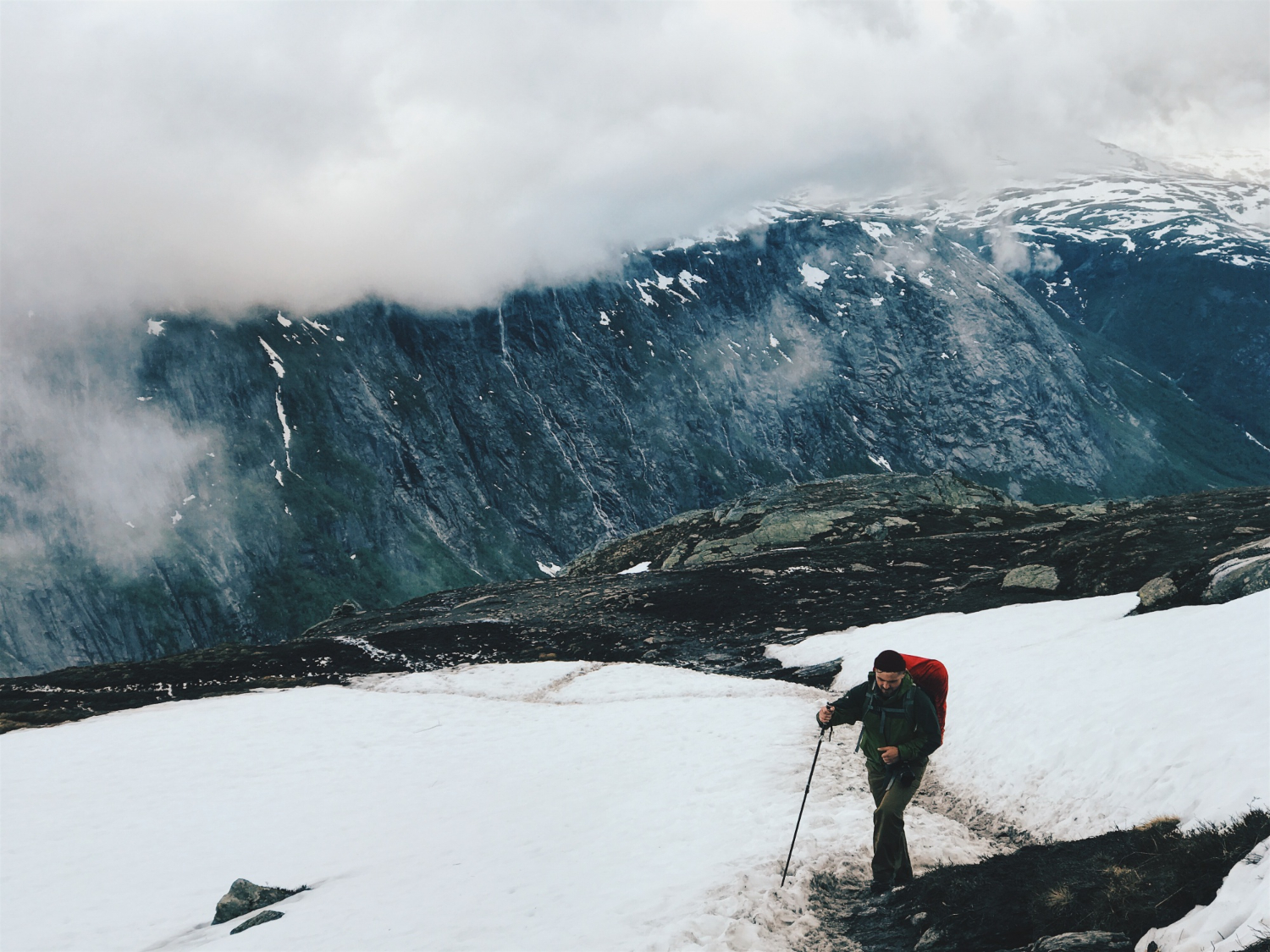
- Level of Difficulty: The trek from Khullara Camp to Pangarchulla Peak summit is considered to be challenging due to its steep ascent and high altitude. The terrain involves rocky trails, scree slopes, and possibly some snow patches, particularly in the early season. Trekkers should be physically fit, acclimatized to high altitude, and have prior trekking experience.
- Route:
- The route from Khullara Camp to Pangarchulla Peak summit starts with a gradual ascent from the campsite, following a well-defined trail through alpine meadows and rocky terrain. As you gain elevation, the trail becomes steeper and more challenging, with sections of scree slopes and loose rocks. Trekking poles may be helpful for stability, especially during the ascent.
- The final stretch to the summit involves a steep climb, possibly with some scrambling over rocks. The trail may narrow and become more exposed as you approach the peak. The route is marked by cairns or trail markers, but it’s important to proceed with caution and follow the guidance of your guide or trek leader, especially in areas with difficult terrain.
- Views:
- The trek to Pangarchulla Peak summit offers breathtaking views of the surrounding Himalayan peaks, including Nanda Devi, Trishul, Chaukhamba, and Kamet, among others. As you ascend higher, you’ll be rewarded with panoramic vistas of snow-capped mountains, deep valleys, and alpine meadows stretching out below. The summit of Pangarchulla Peak provides a spectacular vantage point to admire the beauty of the Garhwal Himalayas, making the challenging trek well worth the effort.
- Duration:
- The trek from Khullara Camp to Pangarchulla Peak summit and back typically takes around 8-10 hours, depending on your pace, weather conditions, and trail conditions. It’s advisable to start early in the morning to allow plenty of time for the ascent and descent, and to return to Khullara Camp before nightfall. Overall, the trek from Khullara Camp to Pangarchulla Peak summit offers an unforgettable adventure in the heart of the Himalayas, with stunning views and a sense of accomplishment awaiting those who reach the summit.
- Trek Distance –8.5 km – 5/6 Hours journey
- Mode of journey – On foot – 11 Km
- Night Stay – Hotel – on twin share basis
- he trek from Khullara Camp to Dhak Roadhead followed by a drive to Joshimath offers a satisfying conclusion to your mountain adventure. Here’s a breakdown of what you can expect:
- Trek from Khullara Camp to Dhak Roadhead:
- Distance: The trek from Khullara Camp to Dhak Roadhead is approximately 11 kilometers.
- Duration: It typically takes around 5 to 6 hours to complete the trek, depending on your pace and trail conditions.
- Terrain: The trail from Khullara Camp to Dhak Roadhead may involve descending through alpine meadows, forested sections, and rocky paths. The route might also include some gradual ascents and descents.
- Scenery: Along the trek, you’ll be treated to stunning views of the surrounding Himalayan peaks, lush green valleys, and possibly encounter streams or waterfalls along the way. The descent offers a chance to reflect on your journey and soak in the natural beauty of the Garhwal Himalayas.
- Drive from Dhak Roadhead to Joshimath:
- Once you reach Dhak Roadhead, you can arrange for a taxi or private vehicle to drive you back to Joshimath. The distance from Dhak Roadhead to Joshimath is approximately 11-12 kilometers, and the drive usually takes around 30 to 45 minutes, depending on road conditions. The road from Dhak to Joshimath offers scenic views of the mountains and valleys, allowing you to enjoy the last glimpses of the Himalayan landscape before returning to civilization.
- Arrival in Joshimath: Upon reaching Joshimath, you can check into your accommodation and relax after the trek. Joshimath offers a range of accommodation options, from guesthouses to hotels, where you can unwind and reflect on your trekking experience.
- You may also want to explore the town of Joshimath, visit local attractions, or indulge in some delicious Himalayan cuisine at local eateries.
- Trek Distance –286 km – 9/10 Hours journey
- Mode of journey – By taxi
- The drive from Joshimath to Haridwar via Rishikesh offers a scenic journey through the beautiful landscapes of Uttarakhand. Here’s what you can expect:
- Distance: The distance from Joshimath to Haridwar via Rishikesh is approximately 275-300 kilometers, depending on the specific route taken. The journey typically takes around 8-10 hours, depending on road and traffic conditions.
- Route:
- From Joshimath, you’ll initially head towards Rishikesh. The route generally follows the NH58, passing through towns like Chamoli, Karnaprayag, and Devprayag. At Devprayag, you’ll reach the confluence of the Alaknanda and Bhagirathi rivers, where they form the Ganges. This is a significant landmark and offers breathtaking views. From Devprayag, the road continues towards Rishikesh, passing through scenic valleys, dense forests, and alongside the Ganges River. Upon reaching Rishikesh, you’ll continue towards Haridwar via the NH58 or other connecting roads, depending on traffic and road conditions.
- Scenic Views: Throughout the journey, you’ll be treated to stunning views of the Himalayan peaks, lush green valleys, and the sacred Ganges River. The route offers ample opportunities for photography and enjoying the natural beauty of Uttarakhand.
- Mode of Transport: You can hire a taxi or tempo traveler for the journey, depending on your preferences and group size. Taxis are suitable for smaller groups or individuals, while tempo travelers are ideal for larger groups as they offer more space and seating capacity.
- Duration and Considerations: The journey from Joshimath to Haridwar via Rishikesh can take a full day, so it’s advisable to start early in the morning to make the most of daylight hours. Be prepared for some winding roads, especially in hilly sections, and occasional traffic congestion, particularly near towns and cities. Make sure to carry sufficient snacks, water, and any other essentials for the journey, as facilities may be limited along the way.
How to Reach Pangarchulla trek
By Air
Jolly Grant Airport is the airport serving Dehradun, located about 25 km from the city. There is a daily flight from Delhi to Dehradun.
By Train
Take the overnight train to Dehradun from Delhi:
- Nanda Devi Express - Train no: 12205 (Departure: 11:50 PM, Arrival: 5:40 AM)
- Dehradun Express - Train no: 12687 (Departure: 9:10 PM, Arrival: 5:00 AM)
By Bus
There is regular bus service from Delhi to Dehradun, from Delhi’s ISBT Kashmere Gate.
We recommend taking only government buses from ISBT Kashmere Gate. Private buses ply from outside ISBT, and they are not trustworthy.
Usually, buses drop you at Dehradun ISBT. From there, you have to reach Dehradun Railway Station.
Note:
- Pick-up is included in the cost of the trek.
- You will reach Sankri by 5:00 PM.
- Food from Dehradun to Sankri is not included in the trek cost.
- Transport will be arranged from Dehradun Railway Station at 6:30 AM.
Inclusions
- Accommodation (Guest house, Home stay, Camping)
- Trek equipment: Sleeping bag, mattress, tent (twin sharing), kitchen & dining tent, toilet tent, utensils, and crampon (if required)
- Welcome refreshment
- Three times meals (Veg+egg): Breakfast, Lunch, and Dinner
- All necessary permits and entry fees
- First aid medical kits, stretcher, and oxygen cylinder
- Mountaineering qualified & professional guide and support staff
- Transport from Dehradun to Sankri and return (According to itinerary)
- Porter or mule charges for carrying camping equipment and rations
- Morning Tea & Evening Tea with snacks
- Guide Charges
- Hot drinking water
- Trek completion certificate (Approved by Outside Explorers)
- Dry fruits, chocolates, biscuits, toffees provided during the trek
Exclusions
- Porter/mule for personal bags
- Any meals or services not mentioned in inclusions
- Any charges for video cameras or still cameras
- Charges for soft drinks or any other beverages
- Personal expenses such as tips, laundry, or telephone calls
- Any costs arising from unforeseen circumstances like landslides, bad weather, or roadblocks
- Food during transit
- Insurance
- Mules or porter to carry personal luggage
- Anything not specifically mentioned under the inclusions
- Any kind of emergency evacuation charges
🏔️ Things to Carry for This Trek
🧳 Essentials
- 🆔 Government ID (Aadhar, Passport, etc.)
- 📄 Permits & Trek Bookings
- 💵💳 Cash (Limited ATMs in Remote Areas)
- 📍 Trek Map & Itinerary
🎒 Backpack & Gear
- 🎒 Backpack (50-60L) with Rain Cover
- 🥾 Good Quality Trekking Shoes
- 🦯 Trekking Pole
- ⛺ Sleeping Bag (if required)
- 🔦 Headlamp / Torch with Extra Batteries
🧥 Clothing & Accessories
- 🧥 Waterproof Jacket / Windcheater
- 🩳 Quick-Dry T-shirts & Trek Pants
- 🧤 Woolen Gloves, Socks & Cap
- 🕶️ UV Protection Sunglasses
- 🩲 Thermal Innerwear (for high-altitude treks)
🛠️ First Aid & Personal Care
- 💊 Basic First Aid Kit & Personal Medicines
- 🧴 Sunscreen & Lip Balm (SPF 50+)
- 🚿 Wet Wipes & Sanitizer
- 🦟 Mosquito & Insect Repellent
📱 Electronics & Miscellaneous
- 📱🔌 Phone & Charger
- 🔋 Power Bank
- 📸 Camera / GoPro (optional)
- 🍫 Dry Fruits, Energy Bars & Snacks
- 🚰 Water Bottles / Hydration Pack
Why should I book my trek with Triptoo?
Triptoo offers expert-guided treks, well-planned itineraries, quality camping gear, and 24/7 support to ensure a safe and memorable trekking experience. We handle permits, meals, and logistics, so you can focus on enjoying the adventure.
What type of food we serve on trek?
Is it safe Trek?
Do I need a permit for the trek?
What kind of accommodation is available during the trek?
