

Brahmatal Trek: Trek to a high altitude lake in Mt Trishul's shadow
Difficulty:Easy-Moderate
Best Time to Visit:
- For Snow:Mid Nov to Mid Mar
- For Spring: April, May, and September
Temperature:
- Day: -1°C to 10°C
- Night: -8°C to -3°C
Highest Altitude: 12250 Ft.
Pickup Point: Rishikesh
Brahmatal Trek: Trek to a high altitude lake in Mt Trishul's shadow
Trek to a high altitude lake in Mt Trishul's shadow Some of our top treks are favourites because of the mountain views they offer. Think of Chaukhambha from Deoriatal Chandrashila or Bandarpoonch from Dayara Bugyal. It is difficult to find such magnified views of big mountains like these. However, Brahmatal is a trek that takes the cake. It has a view that beats all of these. It lays bare some of the most beautiful mountain views in India. You are surrounded by the impressive Mt. Trishul and Mt. Nanda Ghunti. The trek takes you through lovely forests and meadows, leading you to a peaceful high-altitude lake. You reap great rewards very quickly. On the second day of the trek, as you emerge from the dense rhododendron and oak forests, you are greeted by a wall of pristine white mountains. The impressive Trishul massif comes into view. As you continue your ascent to Jhandi Top, the views become even more magnificent, placing you at the heart of a spectacular mountain amphitheatre. The trek packs even better surprises at its highest point, the Brahmatal Top. A new set of peaks opens up before you. You see Mt Neelkanth and the Hathi-Gauri peaks. Trishul and Nanda Ghunti stand steadfast. Close and majestic. It’s as if you walk with the mountains throughout this trek. But the Brahmatal Trek is not just about mountain views. It also weaves through some of the finest Himalayan forests, serene lakes, and expansive ridges. Along the way, you experience a sense of timelessness. You walk on ridges that connect to iconic treks like Roopkund. You camp in secluded clearings and trek through trails that hold stories of legends. Accessible to beginners yet rewarding for seasoned trekkers, it’s no wonder that Brahmatal has emerged as one of India’s most popular treks.e.
5 Things We Love About the Brahmatal Trek
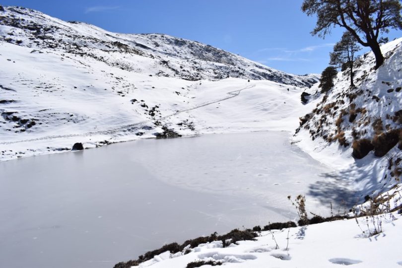
1) High-Altitude Lakes Not many of us know that the Brahmatal Trek takes you to not one but two magical high-altitude lakes. You trek to the Bekaltal lake, surrounded by dense forests of oak, on the very first day. It stands in complete contrast to the Brahmatal Lake, situated in a stark, alpine setting at the cradle of the big mountains.
2) Ridge Walk to Jhandi Top One of the most unforgettable parts of the trek is the ridge walk from Tilandi to Jhandi Top. Emerging from the forest, you step onto an endless meadow. The Trishul massif stands tall like a wall of white before you. You’ll see villages like Deval and Tharali spread out below, while legendary mountain peaks dominate the skyline. These big mountains surround you throughout the trek. While we always talk about Nanda Ghunti and Trishul, the ridge walk from Tilandi to Brahmatal Top shows you many more. You stand a chance to see Mt Kamet, India’s third-highest peak, as well as a few peaks that pop out of Nepal, including Api Himal and Jethi Bahurani.
3) Glimpses of the Legendary Roopkund Trail On the ridge walk to Jhandi Top from Tilandi, you get panoramic views of the Roopkund trek route. Right from the meadows of Ali and Bedni Bugyal to the dip in which the Roopkund tarn is located– you see the entire trail from a birds’ eye view.
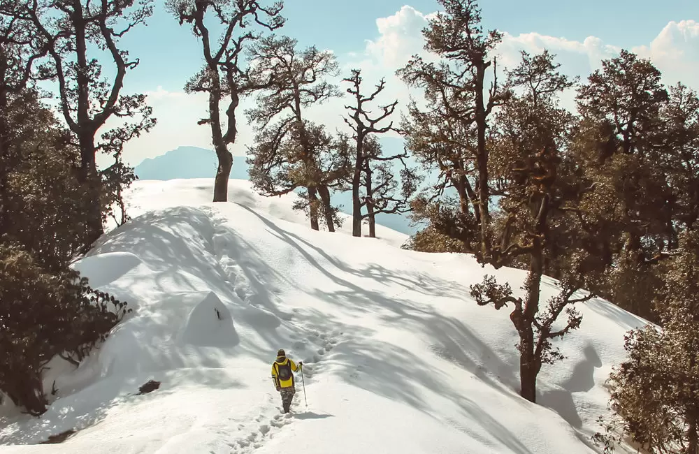
4) The Enchanting Rhododendron Forests The Brahmatal Trek offers some of the most stunning forest trails in the Himalayas. The centuries-old oak and rhododendron forests between Lohajung and Bekaltal are a trekker's paradise. In the rhododendron forest just beyond Bekaltal, trees twist and turn into captivating shapes. Their bare trunks form a smooth, wooden maze while the canopy above creates a natural roof. During spring (March and April), this roof is adorned with a burst of pink flowers.
5) The Gujreni Campsite Nestled in a grassy clearing surrounded by forests, Gujreni offers a perfect mix of seclusion and openness. The campsite is ideal for unwinding after a day’s trek. It’s spacious enough for a stroll, but it also offers pockets of silence where you can sit and soak in the views of the towering peaks in the distance. The atmosphere here is serene, making it one of the most beloved campsites on the Brahmatal trek.
The Brahmatal Trek gives back much more than it demands. You get grand mountain views, beautiful meadow sections, and long ridge walks that lead to a stunning glacial lake. Every day on the trail has something exciting in store. Add to that a glimpse of the legendary Roopkund Trail, and it’s easy to see why this trek is on so many trekkers’ must-do lists.
Factors Contributing to the Difficulty Level:
Trek Duration:
The trek is relatively short, lasting around 04 days depending on the itinerary. Most of the daily trekking distances are between 5 to 7 kilometers, making the journey manageable.
Altitude:
The highest point of the trek is around 11,800 feet (3,600 meters) at Dayara Bugyal. While it’s a significant altitude, the gradual ascent helps prevent altitude sickness for most trekkers. Proper acclimatization is key, but since the altitude gain is not steep or rapid, it is easier on the body compared to higher-altitude treks.
Trail Conditions:
The trail consists of well-defined paths that pass through forests of oak, rhododendron, and pine, open meadows, and small villages. The terrain is mostly gentle, with some gradual ascents, making it less physically demanding. There are no technically challenging sections such as steep climbs, rock scrambles, or glacier crossings.
Physical Fitness Required:
Although the trek is categorized as easy to moderate, a basic level of fitness is recommended. You should be able to walk for 4 to 6 hours a day with a light backpack.
First-time trekkers or those with average fitness levels can complete this trek comfortably with some preparation (such as regular walking, jogging, or light cardio exercises before the trek).Weather Conditions:
Summer: In the summer months (May to June), the weather is usually mild and pleasant, making the trek easier. There may be occasional rain, so waterproof gear is essential.
Winter: In winter (December to February), the trek becomes moderately challenging due to snow-covered trails and cold temperatures, especially at higher altitudes. Walking in snow adds a layer of difficulty, but it’s still manageable for those with the right gear and preparation.
What Do We Do For Safety In The brahmatal Winter Trek?
First of all, the safety of trekkers is our utmost priority, if you see the trek, then there are all the risks, which I do not think about. Safety Guidelines For Trekkers The trek is manageable and enjoyable. With a calm mind and steady determination, you’ll find every step of the journey feels easier and more rewarding. Most people look somewhere and where they are walking, this can cause twitching in your legs and ruin your entire trek. You should always keep your medical kit with you, it saves very crucial time in providing immediate treatment during emergencies. Our Safety Guidelines triptoo always keep a medical kit with every group, such as oxygen cylinders, and medicine to be given in an emergency on the trek. If any trekkers have any more problems, then they are brought back to the base camp by laying them on the stretcher. Our camp in dayara trek is around the tree line where you can not have any problem with Oxygen. In case of any medical problem, the help of your guide or well-informed trekkers should be taken.
Who Can Participate
Age Requirement:
Minimum 8 years.
First-timers are welcome, though prior trekking experience is preferred. Good fitness is a must.
Fitness Criteria:
The trekker should have sufficient stamina to cover 5 km of distance by jogging in 40 minutes without stress or 10 km of distance in 90 minutes without stress
If the trekker prefers cycling, he/she should be able to cycle 8 km of distance in 30 minutes.
Preparation Chart view download
If the trekker wants to carry a backpack, he/she should be able to carry a 10-12 kg backpack. If opt Off-load option then the trekker should be able to carry a 3-5 kg backpack.
If a trekker's BMI is more or less than the normal range (18-29), please consult our Trek Coordinator before booking.
- Total distance- 260 km – 10/11 Hours journey
- Mode of journey – By taxi/tempo traveller
- Altitude – – Lohajung – 7,550 ft to 9,180 ft
- Night stay – Our home stay – on twin/three share basis
- Lohajung is the base camp for the Brahmatal trek. A great way to reach here is from Rishikesh. The drive from Rishikesh to Lohajung is picturesque. You drive through Devprayag, Rudraprayag and Karnaprayag, the confluence of Alakananda with Bhagirathi, Madakini and Pindari rivers respectively. You drive along mountain roads, and through forests. You also get glimpses of the Garhwal mountains in the distance on a clear day. Once you reach Lohajung, you find yourself face to face with the beautiful Nanda Ghunti peak. If you reach before sunset, the colours of the peak will enthral you. Lohajung is at the centre of 12-15 nearby villages. There are a couple of local stores where you can buy jackets, hand gloves, caps, shoes etc. if need be. However, it is advised that you carry all the required things for the trek beforehand and not rely on these shops. You will have a mobile network in most parts of Lohajung. Lohajung, as the locals say, is the place where Goddess Parvati had a war (Jung) with the demon, Lohasur. Hence, the name translates to ‘War with Lohasur.
- Total distance – 4.6 km km – 4/5 Hours journey
- Mode of journey – On foot
- Altitude – Gui Camp – 9,884 feet
- Night Stay – Our Camp site – on twin share basis
- The trek begins from Lohajung central market (chowk). Move upwards from Bisht General Stores (compass direction 3000 NW) on the well-marked, human-made trail. Walkthrough the upper region of Lohajung and then through the forest trail with a few more houses. After a short trek, spot Mandoli village on your left.
- As you climb higher, on your left, you will be able to see the Kali Valley, where Kali and Pindari Rivers join. Follow the water pipes that supply water to Lohajung, as they lie along the trek trail. After some time, cross a small cluster of homes called Budla, on the left. Here, you will find rhododendron trees, which make this part of the trail very beautiful from February to March.
- At approx 8,500 ft, you will find a 10-metre bridge (known as Link-gaad), which will help you cross the stream. After around two hours, you will reach Begum, where you can rest for some time. This place provides splendid views of Navali Bugyal (145o SSE) and Bagdi Bugyal (125o SE). After 10-15 minutes of walking from Begum, you will find another stream. From here, an hour’s walk will bring you to the Gujreni stream.
- During winters, you camp at Gujreni.
- “This campsite is surrounded by Green oak, brown oak, and rhododendrons. It’s inside a clearing and comparatively warmer as the sun rises around 8 and stays till 5 am. I liked this campsite because of the birds I saw. Namely Himalayan Woodpecker, Asian barred owlet, blue-fronted redstart, solitary snipe. I heard the barking dear too. I liked this campsite for its silence and seclusion, in between the forest, sun, and sound of the water stream next to the campsite,”. From here, the trail enters thick Oak forests and keeps climbing moderately. At sections where the mountainside is to your left and the valley to your right, catch the first views of Mt Trishul imposing itself on the horizon. An hour and a half through the forest climb you land at a flat with a small crater in the centre. At one end of the crater, the plateau is the valley of Deval. This place is called Khopdalia. It is a small dried lake. This is the campsite for Bekaltal which lies just above the campsite. Bekaltal is a ten-minute trek up from Khopdalia. It lies surrounded by a thick cluster of Oak trees. The waters of Bekaltal are always brown. The brown water indicates a high amount of dissolved organic matter. Typically, brown lakes are surrounded by forests or wetlands. Dense forests provide dark organic material that dissolves in lake water like a teabag. This dissolved organic material stains the water brown and shades the underwater world. Overall, brown water lakes tend to be light-limited. The algae in these lakes survive through certain adaptations that allow them to adjust to low light levels. These lakes can also sometimes be acidic and contain few fish or other organisms.
- Trek Distance – 2.9 km – 4/5 Hours journey
- Mode of journey – on foot
- Altitude – – 9,180 ft to 10,495 ft
- Night Stay – Campsite – on a twin share basis
- Trek Distance –5 km – 4/5 Hours journey
- Mode of journey – On foot – 05 km
- Trek Distance –8.45 km – 7/8 Hours journey
- altitude – 10190 ft to 7550 ft
- drive duration –260km – 10/11 Hours journey
- altitude – 10190 ft to 7550 ft
- Drive back to Rishikesh. Check out "How to reach the basecamp" section for more details about planning your return journey.
How to Reach Brahmatal Trek
By Air
Nearest Airport: Jolly Grant Airport (DED), Dehradun
Flights Available: Direct flights from Delhi, Mumbai, Bangalore, Hyderabad, Lucknow, Ahmedabad, Kolkata, Jaipur (IndiGo, Vistara, Air India, SpiceJet).
Distance to Rishikesh: 21 km (~40 min by taxi).
Distance to Haridwar: 35 km (~1 hour by taxi).
Airport to Rishikesh/Haridwar Transport:
Taxi: ₹800-₹2000
Bus: ₹100-₹300
By Train
By Bus
From Delhi to Haridwar/Rishikesh:
Departure Point: ISBT Kashmiri Gate.
Bus Type: AC Volvo, Non-AC Sleeper, UTC Govt. Buses.
Travel Time: 5-7 hours
Ticket Price: ₹300-₹1500
Availability: Frequent buses available (day and night).
We recommend taking only government buses from ISBT Kashmere Gate. Private buses ply from outside ISBT, and they are not trustworthy.
Usually, buses drop you at Dehradun ISBT. From there, you have to reach Dehradun Railway Station.
Note:
- Notice: Expenses Not Covered by the Company
- Dear Trekkers,
- Please note that the following expenses are NOT covered in our trek package and must be borne by the trekkers:
- Personal Expenses: Shopping, souvenirs, snacks, beverages, and any extra food beyond the provided meals.
- Travel & Transport: Transportation to and from the trek start point (Haridwar/Rishikesh/Dehradun to Govindghat/Sankri) and any unscheduled transport.
- Accommodation & Meals: Extra stays before or after the trek, special meal requests, or additional food outside the itinerary.
- Food During Transportation: Meals and refreshments during transit (bus/taxi/train/flight) are not included in the package.
- Personal Equipment & Rentals: Trekking gear (trekking poles, ponchos, jackets, gloves, etc.) and backpack offloading charges (mule/porter).
- Medical & Emergency Costs: Any medical treatment, evacuation, rescue operations, hospitalization, medications, and travel or accident insurance.
- Permits & Additional Fees: Any last-minute changes in government permits, forest entry fees, or camera/video charges.
- Tips & Gratitude: Any tips for guides, porters, or drivers (optional but appreciated).
- 💡 Important: Please carry extra cash as ATMs may not be available in remote areas. For any clarifications, feel free to contact our team.
Inclusions
- Accommodation (Guest house, Home stay, Camping)
- Trek equipment: Sleeping bag, mattress, tent (twin sharing), kitchen & dining tent, toilet tent, utensils, and crampon (if required)
- Welcome refreshment
- Three times meals (Veg+egg): Breakfast, Lunch, and Dinner
- All necessary permits and entry fees
- First aid medical kits, stretcher, and oxygen cylinder
- Mountaineering qualified & professional guide and support staff
- Transport from Dehradun to Sankri and return (According to itinerary)
- Porter or mule charges for carrying camping equipment and rations
- Morning Tea & Evening Tea with snacks
- Guide Charges
- Hot drinking water
- Trek completion certificate (Approved by Outside Explorers)
- Dry fruits, chocolates, biscuits, toffees provided during the trek
Exclusions
- Porter/mule for personal bags
- Any meals or services not mentioned in inclusions
- Any charges for video cameras or still cameras
- Charges for soft drinks or any other beverages
- Personal expenses such as tips, laundry, or telephone calls
- Any costs arising from unforeseen circumstances like landslides, bad weather, or roadblocks
- Food during transit
- Insurance
- Mules or porter to carry personal luggage
- Anything not specifically mentioned under the inclusions
- Any kind of emergency evacuation charges
🏔️ Things to Carry for This Trek
🧳 Essentials
- 🆔 Government ID (Aadhar, Passport, etc.)
- 📄 Permits & Trek Bookings
- 💵💳 Cash (Limited ATMs in Remote Areas)
- 📍 Trek Map & Itinerary
🎒 Backpack & Gear
- 🎒 Backpack (50-60L) with Rain Cover
- 🥾 Good Quality Trekking Shoes
- 🦯 Trekking Pole
- ⛺ Sleeping Bag (if required)
- 🔦 Headlamp / Torch with Extra Batteries
🧥 Clothing & Accessories
- 🧥 Waterproof Jacket / Windcheater
- 🩳 Quick-Dry T-shirts & Trek Pants
- 🧤 Woolen Gloves, Socks & Cap
- 🕶️ UV Protection Sunglasses
- 🩲 Thermal Innerwear (for high-altitude treks)
🛠️ First Aid & Personal Care
- 💊 Basic First Aid Kit & Personal Medicines
- 🧴 Sunscreen & Lip Balm (SPF 50+)
- 🚿 Wet Wipes & Sanitizer
- 🦟 Mosquito & Insect Repellent
📱 Electronics & Miscellaneous
- 📱🔌 Phone & Charger
- 🔋 Power Bank
- 📸 Camera / GoPro (optional)
- 🍫 Dry Fruits, Energy Bars & Snacks
- 🚰 Water Bottles / Hydration Pack
Why should I book my trek with Triptoo?
Triptoo offers expert-guided treks, well-planned itineraries, quality camping gear, and 24/7 support to ensure a safe and memorable trekking experience. We handle permits, meals, and logistics, so you can focus on enjoying the adventure.
What type of food we serve on trek?
Is prior trekking experience required?
Do we need a guide for the brahmatal trek?
Is there mobile network coverage?
Do we need permits for the brahmatal trek?
